Harlinger VOC-commandeur ontdekte de archipel in de zeventiende eeuw
Door: René Attema
Op zoek naar goud, nieuwe handelsgebieden en een noordelijke doorgang naar Europa zette namens de Verenigde Oostindische Compagnie de van Harlingen afkomstige commandeur Marten Gerritsz Fries in 1643 als eerste Europeaan voet aan wal op Sachalin en bezocht hij verschillende eilanden van de Koerilen, een archipel gelegen in de verre oostelijke uithoek van Rusland. De verslechterende weersomstandigheden dreven hem terug.
Fries was aanleiding voor de internationaal bekende Russische fotograaf Oleg Klimov (1964) Harlingen te bezoeken en in 2020 benaderde hij mij voor zijn project; een fotoboek en een reizende tentoonstelling in Rusland en Nederland. In 2018 had ik namelijk een boek geschreven over de ontdekkingsreis van de Harlinger. Mijn tekstuele bijdrage aan zijn fotoboek betreft het verhaal van Fries. ‘Calamity Islands’ slaat op de rampzalige gebeurtenissen die de eilandengroep in de loop van de geschiedenis is overkomen.
Full Story of Harlingenboeit.nl
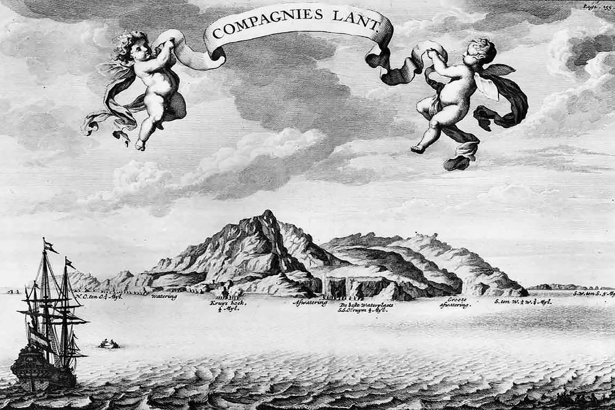
Figure: Plate of “Compagnies lant” , i.e. Land of the United East Indian Company (VOC). “Compagnies Lant” was the name given by Marten Gerritsz Fries to the present Kuril island of Urup . The Kuril Island of Iturup was called Staten Eylant , i.e. Island of the States General ( the Dutch Parliament). The strait between these two islands was called “Vries” and has kept that name (Russian: “Пролив Фриза”). The transcription of the Russian name “Proliv Friza” is also the internationally accepted name.
This illustration is part of a series of 7 coast profiles and some maps and plates of the Kuril Islands (and also partly of Hokkaido and Sakhalin) made by the crew of the Dutch fluyt “Castricum” in 1643 during the expedition led by Marten Gerritsz Fries. They are the first images of the areas to the North of Japan and were only published by Nicolaas Witsen “Noord en Oost Tartarye – (North and East Tartary) was written by the Amsterdam mayor and amateur scholar Nicolaas Witsen (1641-1717) and its first edition appeared in 1692.
In the following quotation from Witsen’s book Compagnies land (Urup) is represented as an island near the west coast of America:
“Of the many drawings that I have in my possession showing the lines of the shores of the lands of Jesso, only three will be included here … Staeten Land and the Bay of Good Hope, in addition to Compagnies Land, … , the way it was presented to the Dutch.
A Channel between Compagnies Land and the American mainland, over half a degree wide, is included in a map of the Dutch East-Indian Company, which makes Compagnies Land an Island, about seven or eight miles long. At 42 degrees, one finds the south-sides of Jesso and of Compagnies Land, with the coast of America behind it, at 46 and 47 degrees”.


